As lockdowns ease and we head into summer, many Australians have started thinking about their beach holiday. For most people, a beach involves sun, sand, salt, and waves. A beach is a beach – right?
For coastal scientists and engineers, it’s a little different. We wonder how these beaches are made and why they are so different.
Australia has over 35,000 kilometres of coastline to explore, and our beaches can differ radically. In Australia’s south, where tides are smaller and waves bigger, we get high energy beaches with lots of surf and sand. The north’s larger tides and smaller waves mean the beaches look quite different – they’re flatter, with big intertidal zones. Some even have mud instead of sand.
To pique your interest, here are six beaches from around the country with special characteristics, all well worth exploring on your summer road trip or beach holiday.
1. Sandy Cape – end of the line for the sand islands
K’gari (Fraser Island), Queensland.
Waves and storms along the east coast, from the New South Wales/Victoria border to K’Gari in Queensland, usually come from the south and southeast. This drives longshore sediment transport, a process where sand is moved up the coast by waves and wave-driven currents.
As the sand moves along the NSW coast and into Queensland, it beach-hops its way north, encountering natural barriers like headlands as well as human barriers such as breakwaters. Sand will often skirt these barriers in pulses, as tends to happen at Byron Bay.
As the coast turns to the west in southeast Queensland, the sand keeps getting pushed north. That’s how Australia got the largest sand islands in the world: Minjerribah (South and North Stradbroke), Mulgumpin (Moreton), Yarun (Bribie), and finally K’gari.
The northernmost point of K’gari, Sandy Point, marks where the sand heads underwater, moving along the continental shelf before dropping off the edge and sliding down the slope into the deep abyssal plains.
If you make it to this beach, you can see sand being swirled away into deeper water – the very end of the above-water part of the cycle.
2. The Funnel – the biggest tides in Australia
Collier Bay, Western Australia
The Kimberley region of Australia is home to the biggest tides in the country. Unfortunately, there aren’t many tide gauges in this area, with over 1,000km between instruments in places. So, to find the beach with the biggest tides, we either have to collect more data or use a computer model.
When we model the tides for every Australian beach, The Funnel in Collier Bay comes out as the beach with the biggest tides. Its range is a whopping 13.5 metres!
Getting to this beach might be tricky as you’ll need to arrive by boat. But it would be worth the trip, as the beach at high tide is composed of cobbles and likely sand and mud at low tide. Watching the tide roar in would be something to see – just watch out for crocs!
READ ALSO: 36 hours in Jervis Bay: beaches, dolphin cruises and maritime history

3. Goolwa Beach – the high energy beach
South Australia
When rivers as big as the Murray – whose basin covers one-seventh of mainland Australia – meet the ocean, they normally form huge deltas like the Mississippi or the Nile.
But because of Australia’s age, low rainfall and water extraction for agriculture, the Murray-Darling Basin only delivers a relatively small amount of water and sediment to the coast. So instead of a classic river delta at the end of the Murray, unusually, we have a beach system.
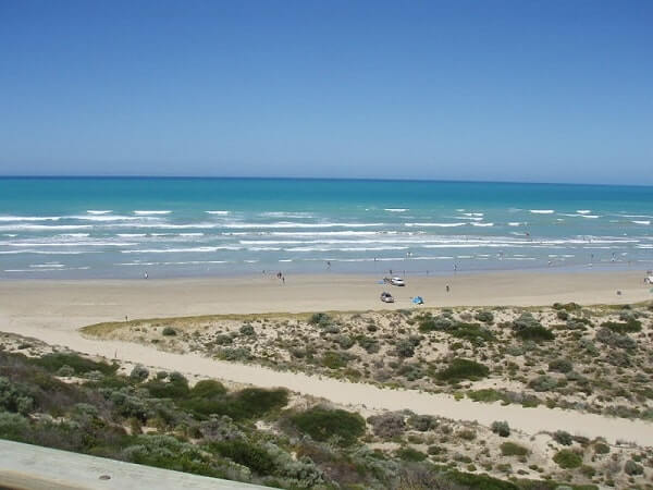
Goolwa Beach is part of this system, its fine sands representing the last barrier to the mighty Murray River on its journey to the ocean. The beach is also exposed to the huge waves rolling in from the Southern Ocean. That makes it one of our highest energy beaches – so much so it’s the archetype of the high energy beach type called “dissipative” in our Australian beach classification system.
4. Amity Beach – the beach with sinkholes
Minjerribah, Queensland
The islands of Minjerribah (North Stradbroke) and Mulgumpin (Moreton) form the barrier separating Moreton Bay near Brisbane from the Coral Sea. Between them lies Rainbow Channel through which the tide flows in and out of Moreton Bay.
These fast tidal currents cause large amounts of sand to form shifting sand shoals on both the ocean and bay sides of the channel.
Amity Beach sits on the edge of this channel and the constantly changing dynamics of this system cause “sinkholes” to occur regularly on this beach. Rainbow Beach near K’Gari is better known due to its habit of swallowing cars, but Amity Beach is unique. Why? Because the sinkholes always occur in the same place.
That makes it the only place in the world where scientists and engineers can reliably observe this amazing phenomenon to work out why sinkholes occur and how they work.

5. Shell Beach – walk on millions of shells
Shark Bay, Western Australia
Most of us tend to think of beaches as being made up by sand, but they don’t have to be. Beaches can be made of mud or cobbles or even just shells.
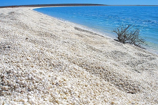
Shell Beach in Shark Bay is a rarity as it’s almost entirely made up of trillions of shells, with the piles up to 10m deep.
These shells all come from one mollusc, the Fragum cockle. The reason there are so many of these shells is because the waters of Shark Bay are saltier than the ocean.
This hypersaline environment makes it hard for most species to survive. That means the Fragum cockle has very few competitors or predators and can proliferate. Just remember to bring some footwear!
6. Bengello Beach – a time capsule made of sand
New South Wales
Coastal scientists and engineers love data about beaches, and especially long-term records of how much sand is on a beach.
Bengello Beach in southern NSW represents the longest record of beach surveys in Australia with measurements every 2-6 weeks since January 1972.
These measurements have captured beach erosion during storms and its subsequent recovery. Data like this underpins models forecasting how our beaches will respond to climate change.
Bengello is also a living snapshot of beach evolution, capturing the way many of Australia’s beaches have changed since sea level stabilised at about today’s level after the last ice age.
If you walk from the road to the beach, you pass over ridges of ancient sand dunes. These formed as the beach slowly built out towards the sea over the last 6,000 years, as waves and currents piled up more and more sand on the beach.
When road-tripping to Australia’s beaches, remember to check local weather and marine forecasts to make sure it’s safe to swim and leave only your footprints behind. And if you make it to any of these beaches, why not share your knowledge about their significance with your travel buddies?
Associate Professor in Coastal and Marine Science, University of Newcastle
This article first appeared in The Conversation. You can read it here.


